About 5 years ago I started getting back into RPGs and was delighted to find a thriving DIY scene utilising the editions of D&D upon which I had cut my teeth — B/X and BECMI. This was 2015 and of course the OSR scene was already long established (for some people it was just a continuation of the campaigns they'd been playing since 70s, 80s and 90s) but for me it felt fresh and exciting and more than a little weird.
Because I was very much alone in this labyrinth, a lot of energy that would otherwise be spent on game prep — or actually playing — ended up going into innumerable worldbuilding experiments. One of the posts that I returned to again and again was this one by Bat in the Attic:
http://batintheattic.blogspot.com/2009/08/how-to-make-fantasy-sandbox.htmlWhile it probably goes to depths that I don't think I would bother going to now, what's great about this huge series of articles is that it presents a formal procedure: follow the steps and you'll end up with a sandbox in which to drop a party of adventurers.
I wanted to include something akin to this in the first volume of PARIAH but the limits of a 64 page zine put paid to that notion fairly early on and the project was sidelined....
Until now!
Now the time is right for me to put something back into the world and to present:
Setting up a Proto-Neolithic Sandbox Part 1: the Base Map
I use 6 mile hexes in my games, for reasons best explained by the
Hydra's grotto, but also vaguely outlined in the
wilderness supplement I wrote for PARIAH and published on itch.io. You will need one of the following:
- Mapping software such as Hex Kit OR
- Image editing software such as photoshop or gimp. OR
- A sheet of hex paper with at least 12 hexes on its shortest edge:
 |
DOWNLOAD YOUR FREE HEX SHEET HERE, NERDS!
|
I'm going to be describing ONE WAY of making a map digitally, using the real world as a base. If you have your own mapmaking methods use them. I'll be referencing a photoshop file I prepared which you can download here:
Grab a Familiar Territory
The wilderness should be a major character in a pariah campaign, and not just for the myriad spirits that animate it. The wilderness can be an ally or an adversary: it is the provider of sustenance and resources, but is also dangerous and sometimes mysterious. Most importantly it is alive.
The GM brings the world to life in part through their description of the environment. Flora, fauna, topography and climate are all elements for players to investigate, manipulate and utilise in their exploration of the game world. By inserting your fantasy sandbox into a landscape with which you are familiar, you greatly reduce the amount of initial effort you put into your campaign prep!
Above is the map I'm using for a
campaign being played on the atelier hwei discord. If you look at the screen grab from google maps below, you might have worked out that this is very crudely based upon central Vietnam, in particular Quang Nam and Thua Thien-Hue provinces.
 |
Upon reflection there's quite a lot of Laos in this picture
|
I chose this region for two reasons. The first was the rich variety of terrain offered by the mountainous border with Laos, the dense tropical forests and the wetlands around numerous river valleys draining into the East Sea. But the main reason was because of familiarity: though only a fraction of the province where both my wife and son were born (Thua Thian-Hue) is in view, neighbouring Quang Nam and Da Nang are areas which I have had the privilege to explore and experience during the many years I was a guest of Vietnam. The landscape of the Hai Van pass, Annamite mountains and Lang Co bay I feel I have become very familiar with.
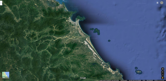
For this exercise (and so that we all come away with something original) I'm going to start with an another part of the world with which I am familiar:
That blue dot in the left centre of the screen grab is my current home, Brighton. This is a regional map of southeast England comprising Kent, Sussex and bits of Surrey & Hampshire. You'll note that in both maps the scale bar is at 10km... there is a reason for this!
Scaling Your Map
The next step is to paste the map into your PSD and scale it to fit your hex grid. At the 10km scale, a 6 mile hex should be a little bigger than the bar. It's not really necessary to get it completely accurate, just use the transform tool, ensuring the proportions are maintain throughout.
I've used a satellite map in the example above but it might be best to grab an image of the road view with terrain, especially for the next step.
The file I provided starts with a hex sheet measuring 20 x 12 hexes, or 120 x 72 miles. This is a pretty big area for most people, but that might be hard to parse for my Russian, American, Canadian and Chinese friends. For those of you living in giant countries, try to imagine that you don't have a car.
Rivers and Watercourses
At this scale a screengrab won't be enough to fill the entire page. This presents you with a choice of three options:
- Zoom out to a larger scale and work backwards from there.
- Scroll around, grabbing more shots at the 10k scale and building a composite.
- Leave a large area of your map blank. This is especially easy to do if you are on the coast.
I went for option 3 for reasons of expediency. Now...
- Position your scaled screengrab behind the layer with all the hexes on it (fill 1 copy).
- Turn of that layer.
- Select "colour range" and click on an area of water on the screen-grabbed map.
- Use the selection to mask the fill layer marked "water".
You should end up with something like this:
Next, use the brush tool to paint over the layer mask in white, revealing the sea beneath:
If you delete the mask on the layer marked CLEAR - AGRICULTURAL you should already see a very simple regional map taking shape!
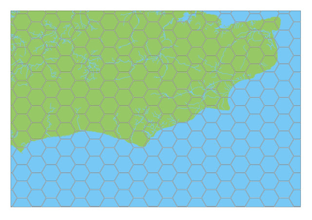
Two things to note here: first, I used a pretty elaborate river map which is probably much more detailed than I really want and secondly, this is not particularly well contrasted.
Without wanted to stray too far far from the BECM/ gazetteer aesthetic, I add a stroke and an outer glow to the water layer to make it pop a bit more:
Then, using the terrain map, personal memory and imaginative embellishment. In the present day this part of the world is characterised by rolling chalk and clay hills and wide tracks of arable pasture criss-crossed by numerous highways and pock-marked by intense urban development. While my intention is not to generate a "historically accurate" or "simulationist" experience, referencing the past (just like referencing genuine geography) grants some interesting prompts. This part of Britain was once heavily forested, so my initial map reflects this:
I've also rationalised the rivers somewhat (and it's probably a little busier for watercourses than a typical BECMI map) but otherwise this is done for the time being.
In the next step, we'll think about what are the forces at play in this otherwise green and pleasant corner of the Here & Now.


No comments:
Post a Comment